Nature-based Solutions (NBSs)
The International Union for Conservation of Nature (IUCN) is one of the leading agencies that introduced the concept of Nature-Based Solutions (NBSs) to stress the importance of biodiversity conservation for climate change mitigation and adaptation. They define the concept as follows: Nature-based solutions are: “actions to protect, sustainably manage and restore natural or modified ecosystems, that address societal challenges (e.g. climate change, food and water security or natural disasters) effectively and adaptively, simultaneously providing human wellbeing and biodiversity benefits”. This broad definition needs to be actually made more concrete for specific purposes. In the case of climate adaptation for Aa of Weerijs catchment, focused on dealing with water shortages and droughts, the 'modified ecosystem' from the definition is resulting from decades of interventions in the area for 'dewatering', using variuos engineering mesures for drainage and fast evacuation of runoff from the catchment. Traditionally, surplus of water has been main challenge in the area, so these interventions were necessary. Currently, the water shortage situation requires introducing of new NBSs that will actually retain more water in the catchment.
Based on previous projects, such as Co-adapt and Pro-Water, several different types of NBSs have already been identified for the area of Aa of Weerijs, including their spatial distribution via so-called 'opportunity maps'. Use the tabs below to explore these NBSs that have been considered in the initial, single-measure adaptation strategies. Combinations of these measures have then be developed for the combined adaptation strategies.
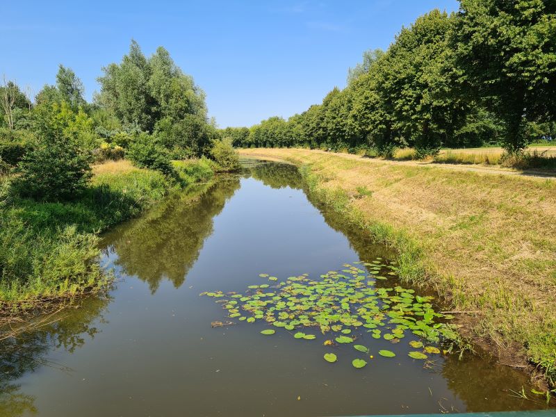
Aa of Weerijs river - summer 2022
Description: Smaller drainage channels (ditches) may be blocked, so that they do not convey water downstream to larger streams. By doing this, some land may be re-gained that may be used for other purposes.
Intended functions: The main function of ditch blocking is to slow down the flow of water downstream, resulting in more water on the surface available for infiltration and subsequent increase of soil moisture and recharge of the groundwater aquifer. Such slowing down will also reduce peak discharge in the small streams.
Modelling method: In the developed hydrological model smaller drainage patterns (not represented by the MIKE 11 river network) are modelled by the conceptual sub-surface drainage in the saturated zone component. Zones with ditch blocking are represented by reducing the value of the parameter 'Drain Time constant' by two-thirds in the relevant modeling cells, mimicking the slowing down of water flow downstream in these zones.
Suitable locations: Mainly in areas close to the main river streams (see opportunity map on the right).
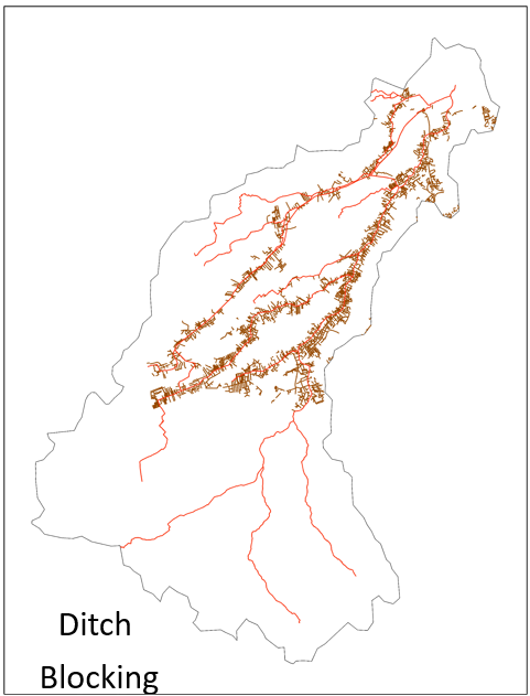
Ditch blocking opportunity map
Description: Wetlands are widely recognized as one of the most effective NBS for water retention and storage. Additionally, they provide valuable aquatic ecosystem services, water purification and they contribute to increase of biodiversity. Different types of wetlands can be envisaged, such as floodplain areas, overflow areas, or larger swamp areas.
Intended functions: Main functions of wetlands restoration are water storage and retention, in addition to other benefits.
Modelling method: In the hydrological model, a new type of vegetation with LAI = 2.5 and RD = 450mm is introduced to represent wetlands. The average values of vegetation parameters are derived from NHI (2007) and Breuer et al. (2003). Additionally, the Strickler roughness coefficient value is provided as 15 m1/3 s-1 in areas where wetlands are restored, and the overland flow detention storage is set at 0.15m. Wetlands have a higher capacity to store organic matter than cropped areas, which leads to modifications in soil hydraulic properties based on the potential changes in soil organic content.
Suitable locations: Wetland restoration areas are mainly close to the main river streams (see opportunity map on the right).
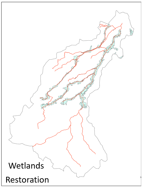
Wetlands restoration opportunity map
Description: Infiltration ponds can be slightly modified swale areas or larger dug pits with bottoms of highly permeable material. Sometimes they can act as sediment traps and if aquatic vegetation develops they may help in improving biodiversity.
Intended functions: The main function of infiltration ponds is to significantly increase infiltration of surface water into the subsurface. This will result in subsequent increase of soil moisture and recharge of the groundwater aquifer.
Modelling method: As the grid resolution of the hydrological model is rather large (500 m), smaller individual infiltration ponds cannot be modelled with their actual geometry. Introduction of such features in the model is done be by increasing the hydraulic conductivity of the top soils. The top 30 cm layer is considered as sandy soil and accordingly its hydraulic properties are updated. Underneath, the soils are kept same as native soils. Additionally, the Strickler roughness coefficient value is provided as 40 m1/3 s-1, and the overland flow detention storage is set at 0.15 m.
Suitable locations: Many areas have been identified as suitable for infiltration ponds (see opportunity map on the right).
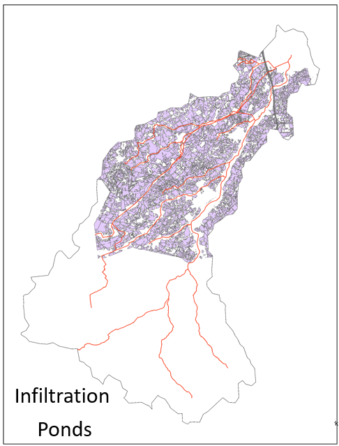
Infiltration ponds opportunity map
Description: Heathlands restoration is intended for land use areas where the currently canopy cover is large, resulting in a high Leaf Area Index (LAI). This leads to reduced water reaching the ground and becoming available for infiltration, as well as increased transpiration, especially in the case of forests.
Intended functions: The primary intended function of heathland restoration is to reduce interception and transpiration from currently forested areas, which results in more water on the ground, available for infiltration and subsequent increases in soil moisture and groundwater recharge. Additionally, heathlands, compared to crops, have a smaller vegetation canopy and offer more resistance to flow, making them conducive to infiltration.
Modelling method: To model heathland restorations, vegetation parameters are changed, namely LAI and RD (both are reduced when changing land use from forest or crop area to heathland). These values are taken from NHI (2007). Additionally, the Strickler roughness coefficient value is modified in areas where heathlands are restored.
Suitable locations: Significant areas have been identified as suitable for heathland restoration (see opportunity map on the right).
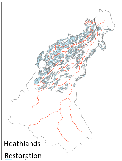
Heathlands restoration opportunity map
Description: Although trees have high capacity for interception and transpiration of water, which eventually evaporates, they can also increase infiltration and water retention capacity in the soil.
Intended functions: Trees increase infiltration and soil water retention capacity in areas with rather impermeable, mostly bare soils. The presence of trees also contributes to enhanced flow resistance, enabling the catchment to retain water for more extended periods.
Modelling method: In the hydrological model tree planting is implemented by modifying vegetation parameters (LAI and RD), and by modifying soil hydraulic properties to capture the influence of the roots on infiltration and water retention capacity. Additionally, the Strickler roughness coefficient value is modified in areas where trees are restored. Similarly to wetlands, trees have a higher capacity to store organic matter, resulting in increased water holding capacity under the trees. To incorporate this process into the modelling, soil hydraulic properties are adjusted based on potential changes in soil organic content.
Suitable locations: Significant areas have been identified as suitable for tree planting (see opportunity map on the right).
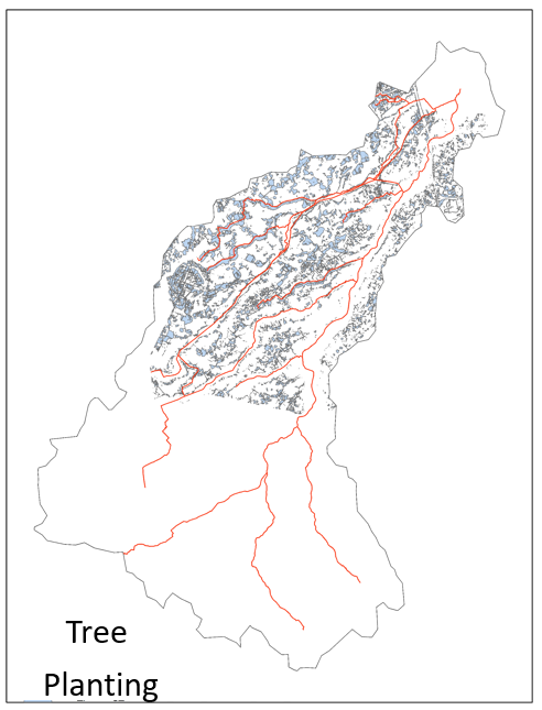
Tree planting opportunity map
Description: This NBS is about installing small barriers in the bottom of smaller water streams and brooks, made of stones, rocks and fallen trees. These act like natural barriers to water flow. Such measures can also decrease erosion of the river bed.
Intended functions: The main function is again to slow down the water flow downstream and allow more time for infiltration.
Modelling method: This NBS is tested in smaller brooks and tributaries represented in the MIKE 11 river network. To simulate the effects of introducing natural barriers, such as stones or fallen trees, weirs are incorporated in these channels to represent the barriers.
Suitable locations: Limited number of brooks have been identified for this strategy (see opportunity map on the right).
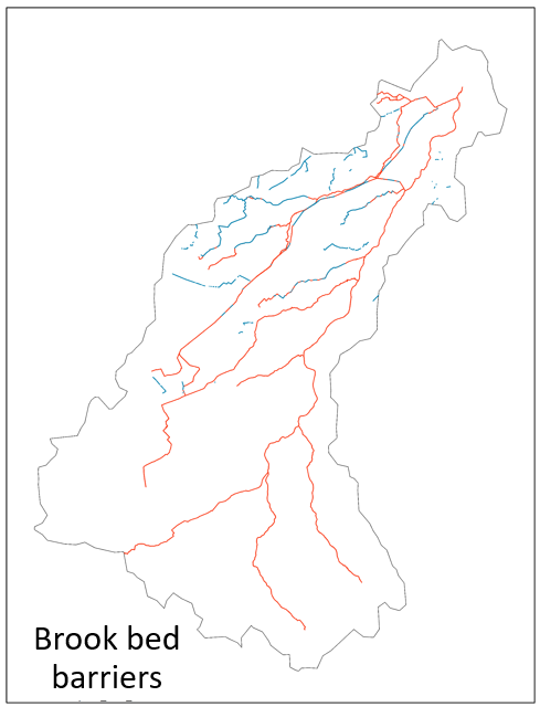
Brook bed barriers opportunity map
© Copyright EIFFEL project. All Rights Reserved. Contact: IHE Delft